
BeiDou: China’s GPS Challenger Takes Its Place On World Stage – Analysis
By NDU Press
By David H. Millner, Stephen Maksim, and Marissa Huhmann*
Global navigation satellite systems (GNSS) provide a service many people take for granted. The GNSS applications people use fall into five major categories: location (determining a position), navigation (getting from one location to another), tracking (monitoring movement of people or objects), mapping (creating maps of the world), and timing (calculating time). Generally, a GNSS has a constellation of at least 24 satellites in medium-Earth orbit (about 12,550 miles high) spread out around the world to deliver global service.1 Such GNSS capabilities are considered so essential that countries and alliances are simply unwilling to rely on each other for a system that is now considered indispensable to sovereignty. GNSS supports millions of applications that track and analyze our everyday lives—from farming, to finance, to reliable Internet. Simply put, it has become a vital service.
GNSS were created almost 50 years ago when U.S. scientists pioneered a global positioning system (GPS). Today, four countries operate GNSS: the United States has GPS, Russia has GLObal NAvigation Satellite System (GLONASS), the European Union (EU) has Galileo, and China has the BeiDou Navigation Satellite System, usually referred to as “BeiDou.” Japan and India have regional systems, and even the United Kingdom is planning for its own constellation since leaving the EU.2
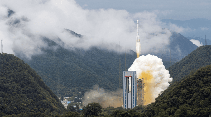
With the launch of its final satellite to reach full system capability, China completed BeiDou in June 2020, and much has been made of the system and its features thus far.3 But BeiDou is only the latest GNSS to come online since the United States developed GPS. Although much speculation and debate exist, it remains unclear if BeiDou will matter to the United States and other Western powers. An examination of the various types of GNSS reveals differences in their development and military use/adoption as well as in international response to them. This closer look sheds light on the likely impact of BeiDou, as it considers the system’s integration with China’s Belt and Road Initiative (BRI), the relationship with Russia and the EU, security concerns, and relative accuracy. A careful analysis of BeiDou and the multi-GNSS environment reveals that, although BeiDou does not represent a technological coup for the Chinese, it does constitute an incremental erosion of American technical prestige by presenting a viable alternative to GPS in an important sector that billions of people around the world use every day.
GPS
GPS is the first and still predominant GNSS—so much so that using satellite navigation is synonymous with the initialism GPS. GPS was created in the early 1970s, when the Department of Defense (DOD) wanted to guarantee a stable, accessible satellite navigation system for military use. DOD launched its first Navigation System with Timing and Ranging satellite in 1978; the 24-satellite system reached fully operational capability (FOC) in 1993.4 DOD is constantly working to improve its satellites and the system; the latest block of GPS satellites, GPS III/IIIF, launched in 2018. These improvements help maintain GPS as the gold standard of GNSS.5 As of June 2021, a total of 31 operational satellites were in orbit, including old and new satellites and on-orbit spares.6 GPS currently delivers two levels of service: Standard Positioning Service, which is available to all users on a continuous, worldwide basis, free of any direct user charges; and Precise Positioning Service, whose access is restricted to the U.S. Armed Forces, U.S. Federal agencies, and selected allied armed forces and governments.7
In the 1980s, President Ronald Reagan promised civilians they could gain access to GPS, but a feature called Selective Availability deliberately degraded location accuracy. This intentional degradation of GPS signals was meant to aid national security, as the feature allowed only “U.S. military and allies to access the second GPS signal for better accuracy.”8 However, the Selective Availability policy increased the error for civil and commercial users by a considerable amount: 50 meters horizontally and 100 vertically.9 Users became wary of U.S. intentions and ownership of GPS. In May 2000, President Bill Clinton signed a law discontinuing Selective Availability. Then, in 2007, DOD stated it would buy future satellites without the feature, and it has done so with the GPS III/IIIF satellites. Although this shift from Selective Availability has increased civil reliance on GPS, other countries nonetheless have moved forward with developing their own GNSS so as not to rely on the U.S. system.
GPS was developed by the U.S. military; however, the system boasts availability to users worldwide. The 2010 National Space Policy encouraged GPS- and GNSS-related international cooperation.10 The policy directed the United States to “engage with foreign GNSS providers to encourage compatibility and interoperability, promote transparency in civil service provision, and enable market access for U.S. industry.”11 The policy also states that the United States may use “foreign positioning, navigation, and timing (PNT) services . . . to augment and strengthen the resiliency of GPS.”12
GLONASS
In keeping with its pattern of imitating U.S. technology, the Soviet Union decided to field its own GNSS. Development of GLONASS began in 1976, only 3 years after the United States started work on GPS.13 GLONASS provides “real-time positioning and speed data for surface, sea, and airborne objects around the world.”14
The first generation of the GLONASS constellation was fully populated in 1996, but there was a gap in service between Kremlin governments: Only 7 of 24 satellites were still in operation in 2002, which hurt the system’s credibility.15 Eager to regain its previous glory, the Russian Federation fully populated GLONASS, reaching FOC on December 8, 2011. The current generation once again features a constellation of 24 satellites. Active satellites boast longer design life, superior electronics, more capable radios, and sturdier hardware.16 As in the case of GPS, military use and applications, such as precision-guided munitions, drove GLONASS requirements. GLONASS is an unabashedly military system, operated by the Russian Aerospace Defense Forces.17 Because the system is global, the Russian military uses GLONASS in operations worldwide, such as recent actions in Syria.18 Adoption of GLONASS was slow, even inside the Soviet Union and Russia.19 However, Russia pushed international adoption around the time GLONASS regained full operational capability.
An agreement in 2000 allowed China not only to use GLONASS for basic navigation but also to field GLONASS-guided munitions.20 Multiple sweeping agreements with China in 2019 include both the use of GLONASS (discussion of a previous GLONASS-BeiDou agreement follows later in this article) and interoperation with ground radar stations built to support BeiDou.21 In 2008, Brazil signed up to use and help develop GLONASS as part of two major agreements on military technology.22 In 2010, Russia signed an agreement to share the GLONASS high-precision signal with India.23 Also in 2010, Ukraine signed an agreement with Russia to help develop GLONASS, after having agreed to help the EU establish Galileo just 5 years before.24 Then, in 2013, Russia and Belarus signed a sweeping military and regulatory agreement that included GLONASS.25 On the consumer front, Garmin and many cellphone manufacturers began supporting both GPS and GLONASS in 2011. These combined GPS/GLONASS multi-GNSS chipsets for cellphones and car navigation systems established the design paradigm used by receivers in common use today that support GPS, GLONASS, Galileo, and BeiDou.26
Galileo
Galileo is the European GNSS. The European Commission and European Space Agency built Galileo together to provide their member states with an independent, European alternative to GPS or GLONASS, as those systems can be degraded or denied by their owners at any time (though the United States has since pledged not to degrade GPS).27 Galileo went live in 2016 and currently has 26 satellites in orbit; it will likely reach its goal of 30 satellites in the near future, as it recently suffered a launch delay.28 Galileo currently provides all of its planned services, but performance will be enhanced when all satellites come online. Galileo delivers an open, free-to-the-public service and a more accurate Public Regulated Service that is restricted to military and emergency services.29
In contrast to its three “peer” services, which tout precision-guided munitions that use a secure signal, Galileo is a “kinder, gentler” system run by civilians instead of the military. Galileo has 28 partner nations, and its Public Regulated Service security modules must, by law, be produced in the EU to safeguard the hardware and software’s intellectual property. The regulated service requirements present obstacles to precision-guided munition manufacturers, which would need that information to implement Galileo-enabled guidance in their weapons.30
During the development of Galileo, significant tensions arose between the United States and the EU over the frequency of its Public Regulated Service. The EU had planned to use a frequency range that overlapped GPS’s military frequency. The frequency overlap would have prevented the United States from jamming Galileo’s high-precision service in a wartime scenario without also jamming an encrypted GPS frequency specific to the U.S. military. The United States also had serious concerns about China’s intentions to become a full member of the Galileo program. The EU eventually agreed to alter the planned frequencies and terminate Chinese involvement.31
The EU cooperates with various intergovernmental organizations and nations around the world to promote Galileo and leverage it to help EU businesses.32 Galileo has already been successful in receiving industry approval; in 2019, the technology to receive Galileo signals was incorporated into 1 billion cellular phones.33 Given the historically cooperative nature of Galileo, as well as its minimal militarization, Galileo will likely provide the United States with beneficial augmentation to GPS.
BeiDou
China decided to develop BeiDou after the 1995–1996 Taiwan Strait Crisis, when an unexpected disruption in GPS caused the People’s Liberation Army to lose track of its ballistic missiles fired over the Taiwan Strait.34 China decided it could not afford to repeat such an incident and needed to invest in its own satellite-based PNT system.35 Even though China had a standing agreement with Russia to use GLONASS for basic navigation and GLONASS-guided munitions, China persisted with its plan to develop BeiDou.36 Given China’s emergence on the world stage and desire for recognition, this move is not surprising; Beijing desires a GNSS that it can maintain complete control of.
BeiDou is currently on its third generation of satellites. In 2000, BeiDou-1 was completed and began to provide PNT services to China only; in 2012, BeiDou-2 was completed and began to provide service to the Asia-Pacific region.37 The third and final phase of the project, BeiDou-3, hit a milestone in 2018 when it began offering services globally. BeiDou-3’s preliminary system was completed with the launch of its final satellite in June 2020.38 BeiDou uses two different general types of service: Radio Navigation Satellite Service (RNSS) and Radio Determination Satellite Service (RDSS). RNSS functions like other GNSS and was designed to have similar performance. RDSS is significantly different: A ground station using signals from the BeiDou satellites calculates a user’s position. The RDSS approach allows for large-volume message communication and extended coverage.39 However, any employment of BeiDou where ground stations are located allows the Chinese government to monitor a user’s location. Both RNSS and RDSS allow the user to send communications via short message service (SMS), a feature unique among the GNSS to BeiDou. The operational implications for such a feature mean that the Chinese government has a system to broadcast messages to any compatible BeiDou user in the world. The potential applications for such a feature are limitless.
Although every GNSS broadcasts a more accurate signal for only military and government use, BeiDou uniquely provides these sensitive users with information about the status and current accuracy of the navigation signal in real time.40 BeiDou has been widely integrated with the Chinese military since at least 2014, and the military uses the SMS feature heavily; it is ideal for communicating among units and headquarters in remote locations. The military has also integrated BeiDou into its precision-guided munitions, including ballistic and cruise missiles.41 Although China promotes BeiDou worldwide, especially within the Asia-Pacific region and BRI countries, its most developed BeiDou relationship is with Pakistan. As of December 2018, as part of a military cooperation agreement with China, Pakistan was the only country permitted to use the BeiDou restrictive service.42 Pakistan also signed a first-of-its-kind agreement with China in 2013 to install five BeiDou ground augmentation stations and one processing center, allowing greater accuracy in the country.43
On July 9, 2019, the Consultative Assembly of Saudi Arabia agreed on a draft memorandum of understanding to cooperate on the military use of BeiDou. The Saudi Ministry of Defense and the Equipment Development Department of China’s Central Military Commission signed the memorandum. This agreement comes after the Second China-Arab States BeiDou Cooperation Forum, which took place April 1–2, 2020, in Tunis, Tunisia. Before this event, the two countries reportedly agreed in March 2019 to “deepen military collaboration to jointly promote regional peace and stability.”44
China aggressively markets BeiDou to the private sector, especially as part of its BRI in Asian countries. In 2013, electronics leaders Qualcomm and Samsung collaborated to bring to market the first smartphones that included BeiDou; their smartphones and tablets were also the first to track three GNSS—GLONASS, GPS, and BeiDou.45 Together, this marked an important milestone for inclusion of BeiDou in the world consumer electronics market as well as for the synthesis of multiple PNT systems on handheld devices. BeiDou made the transition to consumer electronics faster than did GLONASS, having entered the market at a later point in the maturity of handheld electronics after two other GNSS (GPS and GLONASS) had established demand and precedent. Smartphones began using Galileo in 2016, and it is now common for consumer devices to track using multiple GNSS.46 Clearly, the consumer smart-electronics market saw value in utilizing other sources of PNT.
By the end of 2019, more than 70 percent of Chinese smartphones utilized BeiDou for positioning services—with a purported $57 billion in goods and services tied to the capability. China aims to use BeiDou, together with its fifth-generation cellphone technology, to dominate the market for telecommunications services, which China envisions will include next-generation technologies such as autonomous vehicles. Agreements to use BeiDou under China’s expansive BRI have already been signed with 120 partners.47 More than 30 countries, 400 million users, and 6.5 million vehicles use BeiDou.48 Without abandoning GPS, thanks to multi-GNSS radio chipsets, the world has also embraced BeiDou.
Comparisons
In addition to being a full-fledged GNSS, BeiDou is a critical piece in the digital architecture of China’s BRI. Consequently, China aggressively promotes BeiDou as part of its complete system of wares when it markets to other countries. China has indeed seen a surge of activity regarding BeiDou within the international community in the past few years. Security professionals should anticipate more countries adopting the system or coordinating with China now that BeiDou has achieved FOC.
Somewhat surprisingly, Russia is one of those countries that, despite having GLONASS, signed a joint GLONASS-BeiDou cooperation and compatibility agreement in 2015. This agreement was followed by a joint Chinese-Russian Silk Road Project that “marked the first, large-scale Sino-Russian effort to share, compare, and systematize satellite data” in 2017.49 By 2018, China and Russia were able to agree on the same chipset, giving users “access to the total of GLONASS-BeiDou zone coverage, which spans across 40 functioning satellites” and “encompasses the Earth’s entire surface,” according to GLONASS President Alexander Gurko.50 This move created a technological interdependency between two countries that have long struggled to maintain a peaceful border.
As a GNSS, BeiDou offers a slight improvement over GLONASS in terms of accuracy and availability. When considered as an entire system with additional ground antennas, signal post-processing, and communications, BeiDou is superior to GPS, GLONASS, and Galileo. Time will tell if integration with the BRI makes BeiDou more—or less—appealing to the world.
China’s relationship with the EU’s Galileo is somewhat murkier. China’s aborted participation in Galileo not only gave China BeiDou’s technological underpinnings but also left it seemingly unencumbered by any fallout on the international scene. Comparing the military impact of Galileo and BeiDou directly is difficult because Galileo is civilian-run and not well-suited or marketed for weapons systems. Galileo is not part of a broad infrastructure initiative like BeiDou is with the BRI. The EU provides Galileo to the global community without significant installations in foreign territory or a political agenda; it does not seem interested in marketing Galileo as a replacement for GPS but rather views Galileo as an augmentation or “kinder” alternative (per marketing). In the commercial domain, Galileo, much like BeiDou, has been widely accepted in the international marketplace for incorporation into both hardware and software applications. This level of incorporation will likely soften any political or economic impact from BeiDou on the United States simply by broadening the competition.
Unlike the Huawei 5G cellular network—another part of China’s BRI that the U.S. Government is actively campaigning against in partner nations due to security concerns—BeiDou does not pose an obvious security threat to users outside of Asia, where BeiDou ground stations are installed. Although concerns abound that the navigation signal may be able to install malware into a user’s device, such possibility is highly unlikely, according to industry experts. However, malware could be installed through the BeiDou receiver chip, especially in a Chinese-manufactured device, or if the device uses the two-way transmission messaging service. Two-way transmission is necessary for BeiDou to monitor the location of the user and provide enhanced, post-processed position accuracy. Furthermore, most smartphone manufacturers are not expected to utilize BeiDou’s SMS functionality because the service requires a large amount of power and is not practical in a nondedicated device.51 Thus, while many smartphones in the United States can already employ BeiDou as a GNSS, there is little security risk to U.S.-based users, as U.S. law does not allow the Chinese ground stations, which are required to track BeiDou users, to be installed in U.S. territory.52 The traditional one-way listening activity of receiving PNT is inherently safe from a cyber-intrusion standpoint.
Demand for increased location accuracy—already a driving requirement—spurs innovation and competition in GNSS design. Measurements of accuracy depend heavily on the application and methodology. When solely relying on a real-time fix from orbiting satellites, all four GNSS have roughly comparable performance, given that GLONASS is closing the performance gap.53 However, adding terrestrial antennas and signal post-processing, features that BeiDou is offering right now, promises orders of magnitude enhanced location accuracy that the physics of atmospherics and space flight prevent, thus enabling applications such as self-driving cars that the public yearns for.54 The new capabilities will differentiate the next generation of GNSS.
Analysis
The fielding of modern precision-guided munitions is the most obvious military implication of BeiDou, though China has had guided munitions with that capability for a long time—first through GPS and later through a diplomatic agreement with Russia. The completion of BeiDou does have some potentially positive aspects for the United States and other global competitors. BeiDou will provide redundancy for both civilian and military applications worldwide; most commercial technology now incorporates multiple GNSS to take advantage of that redundancy. This redundancy can have powerful advantages, like being able to receive more satellite signals while in an urban canyon or, while in open spaces, getting more accurate positional data by using multiple GNSS. Militaries and governments worldwide can use BeiDou for redundancy as well. For example, American U-2 Dragon Lady pilots have been authorized to use multi-GNSS as a backup navigation system in case the aircraft’s GPS fails.55 Other U.S. military units could easily take advantage of BeiDou by incorporating similar commercial technologies into their toolkits. The United States should consider allowing the military to use multi-GNSS receivers produced by a trusted manufacturer.
Continued and diversified investment in space by other countries, especially peers and near-peers, reduces the strategic advantage of “nuking space,” whether literally or figuratively. Whereas in times past the overwhelming superiority and number of U.S. space-based platforms made the space domain itself a ripe target in a hot war, worldwide dependence on space, as well as the cost of repopulating constellations, acts as an incentive to preserve space as a global common.
Early on, the United States enjoyed a virtually unchallenged upper hand, as GPS was the gold standard of GNSS; this predominance made other nations dependent on the United States. That this reliance created tension in international relations is evident through the existence of now-multiple allied and adversary GNSS. When only GPS and GLONASS were available, countries worried about their reliance on just one or two systems. Now a solid quorum of GNSS gives all countries, both those with and without their own systems, a higher degree of confidence that they can plan on at least one system being available if another goes down.
Competition breeds innovation, though, and, even before BeiDou, GPS competed with both GLONASS and Galileo in a market that required constant improvements. That said, BeiDou may have applied new pressure. The newest GPS satellites (GPS III, which launched in 2018) will have three times better accuracy, up to eight times improved anti-jamming capabilities, and a longer lasting spacecraft.56 With several global systems currently online, it behooves the U.S. militarily to ensure that GPS remains the GNSS of choice. One addition in GPS III is a new signal that will “make it the first GPS satellite broadcasting a compatible signal with other international GNSS, like Galileo, improving connectivity for civilian users.”57 Of course, innovation requires fresh capital. The U.S. military was projected to spend $1.8 billion in fiscal year 2020 for GPS III, a figure that will likely increase as the United States contends with other GNSS.58 The United States should focus on building the most reliable, accurate, and trusted source of PNT. Copying BeiDou’s two-way communication method of delivering improved positioning accuracy at the cost of revealing user location and costly linear scalability is not a winning strategy in an expanding GNSS marketplace.
As worldwide reliance on GNSS expands, the criticality of these systems to multiple facets of modern life will continue to evolve; as a result, questions of sovereignty will loom as this critical infrastructure will hang, exposed, in the global commons of inner space. Tellingly, it was “desire for political sovereignty and control over a critical infrastructure” that sustained Galileo through years of strained planning and development. The United States should expect more nations to realize that depending on another’s GNSS makes a country exactly that—dependent. 59 If China had decided to forgo pursuing a GNSS when the United States, EU, and Russian Federation had pursued theirs, such avoidance could have been interpreted as a sign of weakness or inferiority, especially in such a high “face culture.” After all, China considered the exposure of its dependence on GPS to be an “unforgettable humiliation.”60 Because an emphasis on public image and a long societal memory are major aspects of Chinese culture, the United States should expect that China will attempt to never repeat this error.
Conclusion
Examining other GNSS programs offers some unique insights into what the United States should expect with BeiDou. Comparing BeiDou with GLONASS and Galileo reveals that, although the Chinese system will not cause a technological sea change in the GNSS ecosystem, BeiDou is significant and deserves attention, since it brings both security concerns and benefits to the United States. Through the lens of Great Power competition, BeiDou signifies another incremental erosion of the status of the United States as the sole superpower. China now offers sympathetic nations a viable GNSS alternative to GPS with highly competitive features that essentially did not exist before. Globally, GPS has been the de facto choice for PNT services because GLONASS was a markedly inferior service, and Galileo is only now coming into its own. BeiDou changes this status quo—it is clearly a better alternative than Galileo and GLONASS.
Despite GLONASS’s rocky start, Russia was eventually successful in fielding its system and garnering international cooperation and use of its GNSS, including sharing GLONASS-enabled precision-guided munitions. Still, while Russia broke GPS’s monopoly, it did not represent a fundamental shift in the status quo, neither was it an adequate replacement for GPS technologically. China has enormous economic, technological, and political advantages over Russia to speed the adoption of BeiDou as an (if not the) international standard of GNSS.
Galileo, set to reach FOC soon, may be aptly described as a demilitarized GPS without the political liability of single-country ownership. Galileo was quickly adopted by industry, and with multi-GNSS receivers already common, inclusion of BeiDou in most devices practically ensures that BeiDou will become the industry standard. It is, however, unlikely that BeiDou will displace GPS as the GNSS of choice for either military or civilian functions worldwide—BeiDou will likely become just another tool in the kit for most applications.
BeiDou does not pose a security threat for American users because the United States will not allow BeiDou ground stations in its territory; however, for nations participating in China’s BRI and taking advantage of the additional capability that ground stations offer, security is a concern. These nations are sacrificing privacy for access to superior service. Geopolitically, China has already sold access to its military-only signal to Pakistan and Saudi Arabia, allowing these countries to use BeiDou-enabled precision-guided munitions, which need not rely on other foreign GNSS, thus complicating any U.S. effort to deny these nations military-grade PNT capabilities directly through GPS.
BeiDou brings some benefits to the United States and the global community. Multi-GNSS receivers provide redundancy, additional features, and better positional accuracy, and BeiDou only deepens these advantages. Chinese investment in BeiDou also reduces the risk of conflict in the space domain, since physical destruction of any satellites puts other satellites in that orbit at risk, making kinetic conflict in space a shakier proposition. Finally, BeiDou forces all systems to innovate or risk becoming obsolete. The United States should take advantage of the benefits BeiDou provides while maintaining a vigilant eye on the security threats and implications that it brings. With the prestigious work of pioneering GPS complete, many other countries now join the United States in space, vying for dominance in navigation. The Nation would benefit from continued technological advances in GPS to keep it the gold standard of GNSS in this increasingly competitive field.
*About the authors: Commander David H. Millner, USN, is the Senior U.S. Defense Official/Defense Attaché in Albania. Major Stephen Maksim, USSF, is Chief of the Engineering Liaison Office at the Air Force Nuclear Weapons Center. Lieutenant Commander Marissa Huhmann, USN, is currently serving as an Assistant Public Affairs Officer at U.S. Pacific Fleet.
Source: This article was published in Joint Force Quarterly 105, which is published by the National Defense University.
Notes
1 “How GPS Works,” GPS.gov, n.d., available at <https://www.gps.gov/multimedia/poster/>.
2 Callum Hoare, “UK Galileo Replacement to Integrate with U.S. GPS as Brexit Inspires ‘New Relationship,’” Express, December 10, 2019, available at <https://www.express.co.uk/news/uk/1215391/Brexit-news-uk-galileo-gnss-satellite-system-us-gps-chris-skidmore-eu-spt>.
3 Andrew Jones, “Final Beidou-3 Satellite Reaches Operational Orbit, China’s Launch Sites Gear Up for July Missions,” Space News, June 30, 2020, available at <https://spacenews.com/final-beidou-3-satellite-reaches-operational-orbit-chinas-launch-sites-gear-up-for-july-missions/>.
4 National Aeronautics and Space Administration (NASA), “Global Positioning System History,” n.d., available at <https://www.nasa.gov/directorates/heo/scan/communications/policy/GPS_History.html>.
5 J. David Grossman, “The Path to a More Resilient and Robust GPS,” C4ISRNET, April 22, 2021, available at <https://www.c4isrnet.com/opinion/2021/04/22/the-path-to-a-more-resilient-and-robust-gps/>.
6 “Space Segment,” GPS.gov, n.d., available at <https://www.gps.gov/systems/gps/space/>.
7 NASA, “Global Positioning System History.”
8 GIS Geography, “Selective Availability in Global Positioning System (GPS),” n.d., available at <https://gisgeography.com/selective-availability-gps/>.
9 Ibid.
10 National Space Policy of the United States of America (Washington, DC: The White House, June 28, 2010), available at <https://obamawhitehouse.archives.gov/sites/default/files/national_space_policy_6-28-10.pdf>.
11 “International Cooperation,” GPS.gov, n.d., available at <https://www.gps.gov/policy/cooperation/>.
12 National Space Policy of the United States of America.
13 Richard B. Langley, “GLONASS: Past, Present and Future: An Alternative and Complement to GPS,” GPS World 28, no. 11 (2017), 44–49, available at <http://digital.gpsworld.com/publication/?m=59713&i=706479&p=49&pp=1&ver=html5>.
14 “Russian Armed Forces Use Glonass Satellites for Aiming in Syria,” GPS Daily, May 17, 2016, available at <https://www.gpsdaily.com/reports/Russian_Armed_Forces_Use_Glonass_Satellites_for_Aiming_in_Syria_999.html>.
15 Langley, “GLONASS: Past, Present and Future.”
16 Ibid.
17 “Russia Launches One More Satellite to GLONASS Fleet,” Geospatial World, May 30, 2016, available at <https://www.geospatialworld.net/news/russia-adds-one-more-satellite-to-glonass-fleet/>.
18 “Russian Armed Forces Use Glonass Satellites for Aiming in Syria.”
19 Langley, “GLONASS: Past, Present and Future.”
20 B. Rivers, “PRC, Russia Close to GLONASS Agreement,” Journal of Electronic Defense, 2000.
21 See “Putin Approves Ratification of GLONASS, BeiDou Cooperation Agreement with China,” Russia & CIS General Newswire, 2019; “Russia Will Be Able to Use 3 Chinese Ground Stations to Correct Satellite Signals—Roscosmos,” Russia & CIS General Newswire, 2019.
22 Imanuela Ionescu, “Brazil-Russia Military-Technical Cooperation: A Fruit of the Post–Cold War World Order,” Military Review 98, no. 6 (2018), 66–79.
23 “Russia, India Ink Agreement to Share GLONASS Signals,” Mint, December 21, 2010, available at <https://www.livemint.com/Politics/kPadhPb6AOduzuZcSB8hjP/Russia-India-ink-agreement-to-share-GLONASS-signals.html>.
24 “Ukraine-Russia GLONASS Agreement,” Ukraine General Newswire, 2010.
25 “Russia, Belarus to Cooperate in Using GLONASS Satellite Navigation System—Agreement,” Russia & CIS Business and Financial Newswire, 2013.
26 Langley, “GLONASS: Past, Present and Future.”
27 European Space Agency (ESA), “Why Europe Needs Galileo,” n.d., available at <http://www.esa.int/Applications/Navigation/Galileo/Why_Europe_needs_Galileo>.
28 “Soyuz Launch from Kourou Postponed Until 2021, 2 Others to Proceed,” Space Daily, May 19, 2020, available at <https://www.spacedaily.com/reports/Soyuz_launch_from_Kourou_postponed_until_2021_2_others_to_proceed_999.html>; European Union Agency for the Space Programme (EUSPA), “Constellation Information,” available at <https://www.gsc-europa.eu/system-service-status/constellation-information>; ESA, “What Is Galileo?” n.d., available at <http://www.esa.int/Applications/Navigation/Galileo/What_is_Galileo>.
29 EUSPA, “Services,” n.d., available at <https://www.gsc-europa.eu/galileo/services>; Jordan Wilson, China’s Alternative to GPS and Its Implications for the United States, Staff Research Report (Washington, DC: U.S.-China Economic and Security Review Commission, January 5, 2017), available at <https://www.uscc.gov/research/chinas-alternative-gps-and-its-implications-united-states>.
30 Tim Vasen, “Is NATO Ready for Galileo?” The Journal of the JAPCC 28 (Spring/Summer 2019), available at <https://www.japcc.org/is-nato-ready-for-galileo/>. At the time of this publication, the author of this article was not aware of any precision-guided munitions designed to use Galileo’s Public Regulated Service, though it is likely they are being developed by European manufacturers.
31 “EU, U.S. Split over Galileo M-Code Overlay,” GPS World, 2002.
32 EUSPA, “International Co-operation,” n.d., available at <https://www.gsa.europa.eu/galileo/international-co-operation>.
33 EUSPA, “Galileo Is the European Global Satellite-Based Navigation System,” updated September 16, 2021, available at <https://www.euspa.europa.eu/european-space/galileo/What-Galileo>.
34 Minnie Chan, “‘Unforgettable Humiliation’ Led to Development of GPS Equivalent,” South China Morning Post, November 13, 2009, available at <https://www.scmp.com/article/698161/unforgettable-humiliation-led-development-gps-equivalent>.
35 Ibid.
36 Rivers, “PRC, Russia Close to GLONASS Agreement.”
37 Rui Li et al., “Advances in BeiDou Navigation Satellite System (BDS) and Satellite Navigation Augmentation Technologies,” Satellite Navigation 1, no. 12 (2020), available at <https://doi.org/10.1186/s43020-020-00010-2>.
38 Jones, “Final Beidou-3 Satellite Reaches Operational Orbit.”
39 Rui C. Barbosa, “Chinese Bolster Navigation System with Dual Beidou Launch,” NASA Spaceflight, November 22, 2019, available at <https://www.nasaspaceflight.com/2019/11/chinese-bolster-navigation-system-dual-BeiDou-launch/>.
40 Ajey Lele, “Space Security Dilemma: India and China,” Astropolitics 17, no. 1 (2019), 23–37, available at <doi.org/10.1080/14777622.2019.1578932>.
41 Kevin McCauley, “Putting Precision in Operations: Beidou Satellite Navigation System,” China Brief 14, no. 16 (August 22, 2014), available at <https://jamestown.org/program/putting-precision-in-operations-beidou-satellite-navigation-system/>.
42 Maria Abi-Habib, “China’s ‘Belt and Road’ Plan in Pakistan Takes a Military Turn,” New York Times, December 19, 2018.
43 Deng Xiaoci, “Pakistan 1st Foreign Nation to Fully Benefit from China’s BeiDou System,” Global Times, May 17, 2017.
44 RWR Advisory Group, “Saudi Arabia Agrees to Cooperate in the Military Use of China’s Beidou Navigation Satellite System,” July 11, 2019, available at <https://www.rwradvisory.com/saudi-arabia-agrees-to-cooperate-in-the-military-use-of-chinas-BeiDou-navigation-satellite-system/>.
45 “Qualcomm Collaborates with Samsung to Be First to Employ BeiDou for Location-Based Mobile Data,” GPS World, November 22, 2013, available at <https://www.gpsworld.com/qualcomm-collaborates-with-samsung-to-be-first-to-employ-BeiDou-for-location-based-mobile-data/>; David Manners, “Qualcomm, Samsung Add BeiDou to Glonass and GPS for More Precise Location Tracking,” Electronics Weekly, November 22, 2013, available at <https://www.electronicsweekly.com/news/business/finance/quslcomm-samsung-add-BeiDou-to-glonass-and-gps-for-more-precise-location-tracking-2013-11/>.
46 “1 Billion Now Use Galileo Smartphones,” GPS World, September 10, 2019, available at <https://www.gpsworld.com/1-billion-now-use-galileo-smartphones/>.
47 Jonathan Shieber, “China Nears Completion of Its GPS Competitor, Increasing the Potential for Internet Balkanization,” Tech Crunch, December 28, 2019, available at <https://techcrunch.com/2019/12/28/china-nears-completion-of-its-gps-competitor-increasing-the-potential-for-internet-balkanization/>.
48 P.W. Singer and Taylor A. Lee, “China’s Version of GPS Is Almost Complete. Here’s What That Means,” Popular Science, March 31, 2020, available at <https://www.popsci.com/story/blogs/eastern-arsenal/BeiDou-china-gps-gnss/>.
49 Mark Episkopos, “Is This the Real Russia-China Alliance America Should Fear?” The National Interest, December 16, 2018, available at <https://nationalinterest.org/blog/buzz/real-russia-china-alliance-america-should-fear-38762>.
50 Ibid.
51 Jim Mollenkopf, Senior Director, Strategic Development Qualcomm Government Technologies, interview with U.S.-China Economic and Security Review Commission staff, October 14, 2016; David Stelpstra, geodetic engineer, TomTom NV, interview with commission staff, October 14, 2016; Engineer, Qualcomm, Inc., interview with commission staff, August 19, 2016.
52 Wilson, China’s Alternative to GPS.
53 Alan Cameron, “K2 Will Drive GLONASS Under 1M,” GPS World, June 20, 2019, available at <https://www.gpsworld.com/k2-will-drive-glonass-under-1m/>; EUSPA, “Services”; Wilson, China’s Alternative to GPS; Lele, “Space Security Dilemma.”
54 Wilson, China’s Alternative to GPS.
55 Eric Tegler, “Why Are U-2 Jet Pilots Wearing Garmin Satellite Navigation Smartwatches?” Ars Technica, March 13, 2020, available at <https://arstechnica.com/gadgets/2020/03/why-are-u-2-jet-pilots-wearing-garmin-satellite-navigation-smartwatches/>.
56 Alan Cameron, “Benefits Coming from GPS III Constellation,” GPS World, April 1, 2019, available at <https://www.gpsworld.com/benefits-coming-from-gps-iii-constellation/>.
57 Lockheed Martin, “GPS III/IIIF: The Next Generation of Positioning, Navigation, and Timing,” available at <https://www.lockheedmartin.com/en-us/products/gps.html>.
58 Stephen M. McCall and Brendan W. McGarry, “FY2020 National Security Space Budget Request: An Overview,” Congressional Research Service, June 7, 2019, available at <https://fas.org/sgp/crs/natsec/IF11244.pdf>.
59 Ivan G. Petrovski, GPS, GLONASS, Galileo, and BeiDou for Mobile Devices: From Instant to Precise Positioning (Cambridge, UK: Cambridge University Press, 2014), xvii.
60 Chan, “Unforgettable Humiliation.”